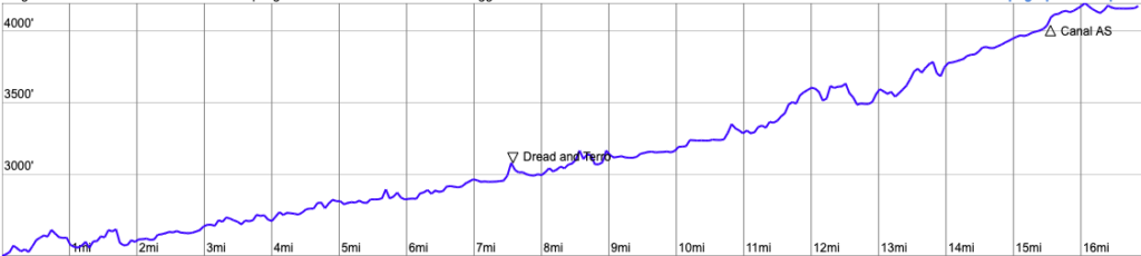
New in 2020! You asked for it, so here you go, a shorter distance! But don’t be fooled. Just because it isn’t as long as the 50K, doesn’t mean that it is an easy race. This course is almost all on the famed Dread & Terror section of the North Umpqua Trail. It’s not dreadful and it shouldn’t strike terror in your heart, but you do get to do quite a bit of climbing. This point-to-point route gives you 3,500 feet of gain and just 1,800 feet of loss on what many call the most beautiful section of the trail.
Please look at this interactive map where you can zoom in and out and change the layers.
The BLM also has an interactive site that explains the different trail segments.
Start to Aid Station 1 (Dread & Terror)
You start this race at the Toketee Campground (this is an aid station for the 50K race too) by running over the North Umpqua River and making a left right away, following the river. About 1.7 miles into this segment, you hit a gravel road (Road 3401). This is where you can pass and really find your position. You will run along this dirt/gravel road for 1.5 miles before meeting the trail again just after the Hot Springs Trailhead. After the Hot Springs Trailhead you enter into the “Dread and Terror” section for the North Umpqua Trail – named by two rangers in 1908 – in reference to the disagreeable possibility of fighting forest fires in the impenetrable thickets of white thorn brush in the area and the steep canyon. You will pass Surprise and Columnar Falls and other unique forms of flowing water.

Aid Station 1 to Aid Station 2 (Canal)
You continue following the river in the narrow canyon slowly gaining elevation. There are a few steep and longer climbs a couple miles out from the aid station, the last being immediately before crossing the North Umpqua River for the last time on a bridge. The climb is steep. Be prepared. It will surprise you. The trail then follows the river before climbing slightly to White Mule/Lemolo Falls Trailhead at Road 2610 where your aid station awaits.

Aid Station 2 to Finish
You will cross over the canal and the road and run a short section of trail (~.75 miles) before hitting Road 2610, crossing Lemolo Lake Dam, climb a short, steep hill and running along the lake at Lemolo Lake Resort and to the FINISH just up from the lake’s edge.
The 17M has 3,500 feet of gain and 1,800 feet of loss.
You have two fully-stocked aid stations in this race. We provide your typical ultra fare: PB&J, crackers and cookies, pretzels, pickles, fruit, GU gels, GU electrolyte drink, soda, and water. Runners are welcome to carry their own food too.
Go Beyond Racing is cupless. You’ll need to bring your own cup for liquid aid at all aid stations. You can refill bladders and bottles too. Read more about what it means to be cupless.
| Aid Station | Segment Distance |
Cumulative Distance |
|---|---|---|
| Dread & Terror | 7.8 | 7.8 |
| Canal | 8.1 | 15.9 |
| Finish | 1.3 | 17.2 |
There is no cutoff for the 17M race!
There is spectator access at the start, at Toketee Lake Campground (your start location), and the Canal aid station Your fans will have to hustle to get from the Canal aid station to the finish line if they want to see you finish. There is no crew or spectator access at any other location on the course. Crews accessing their runners elsewhere, and runners accepting aid from crew elsewhere will be disqualified.
Pacers are not allowed.
There are no drop bags for this race.