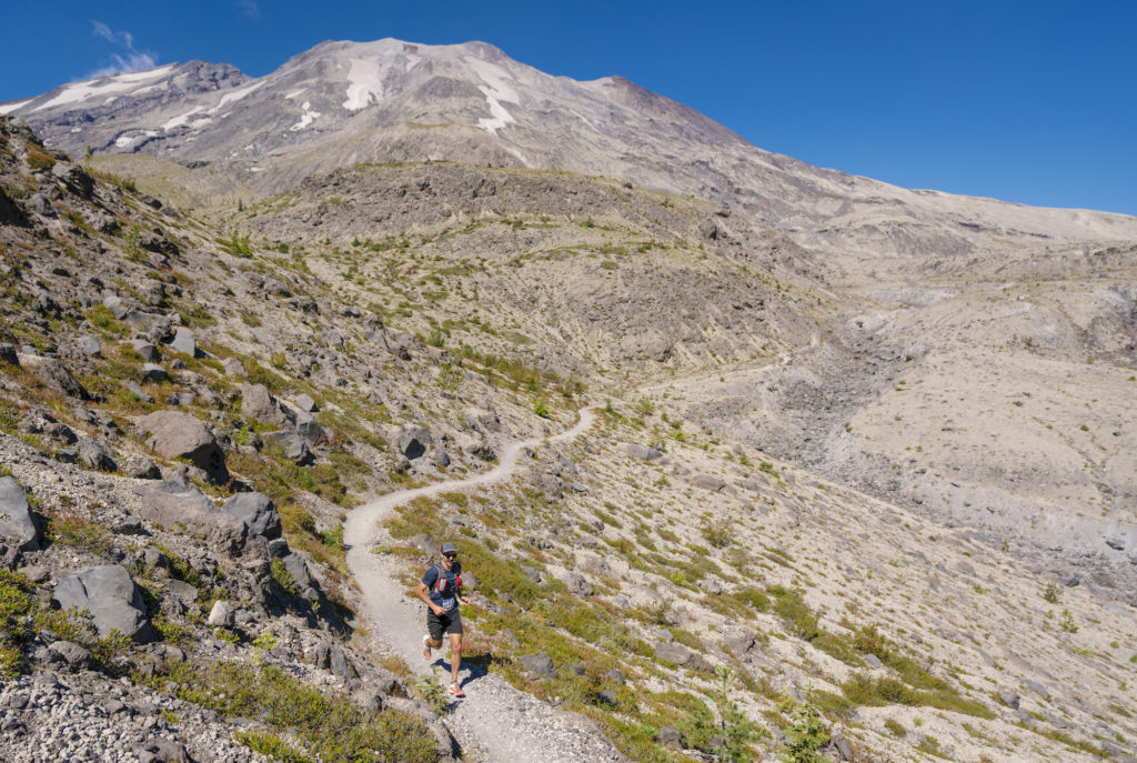
Volcanic 50 is a remote and challenging course with over 7400 ft of elevation gain and loss circumnavigating Mt St Helens, all on rugged, single-track trails covering 32.3 miles. All but 4.5 miles are on the Loowit Trail. You will travel over lava and pumice fields, crossing rivers, through the blast zone as well as through dense forests. Anticipate a finish time more like a 50-miler than a 50K.
You will travel clockwise around the mountain.
Strict cut-off times are established for Aid Station #2 (Toutle) and #4 (Ape Canyon). Runners must leave the aid station by the cutoff time or they are pulled from the race – no exceptions.
Interactive Course Caltopo Map
And for COROS watch users, you can download the route directly to your COROS app and then sync to your watch.
In this section, you will cross a few lava fields. Be on the lookout for course markers [there are also trail markers with logs sticking above a mound of rocks (cairns)] as you will probably be focusing on your footing. Footing will be loose or you will be hopping from one rock to another.
Within a mile after gaining the Loowit Trail, there is a relatively steep climb the lasts for about a mile. At the top of this climb, you will cross-over the main trail leading to the summit of Mt St Helens. Longer stretches of “level” ground awaits for the trip to Butte Camp Aid Station (AS 1) at mile 6.3.
A few miles after aid station 1, you will drop ~1600ft to the Toutle River through dense forest (the most shaded section of the course), reaching the Toutle River Aid Station (AS 2). This is a fully stocked aid station, with filtered water, but you can fill up your bottle(s)/bladders from the river if you choose. Load up on water and calories here as the next section will drain you.
Once you pass the Toutle River Aid Station, there is virtually no shade till you get to within 3.5 miles of the finish. You WILL be exposed to the elements. It can be any one or a mixture of the following conditions: hot, windy, cold, rainy, snowy.
Trail conditions on this section are varied from sandy (just beyond the Toutle River Aid Station) to rocky/sandy (in the blast zone) to great hard compact (in between the sections just mentioned).
You immediately climb ~800ft from the Toutle River. From the top of this climb, you drop in and out of a number of canyons. After these canyons you cross the expanse of the blast zone. Here you will cross a number of small creeks/rivers.
There is a water source (the spring) at around mile 20.3 and this is where aid station 3 is located. This aid station has water (from the spring), electrolyte drink, and gels….and friendly faces. There is not other items or calories here, which is why it is important you load up at the Toutle aid station. Please fill up your water bottle/bladder at this aid station as many run out between here and the next aid station.
About 1.25 miles beyond aid station 3 you will reach the highest point on the course – Windy Pass – at an elevation of 4950ft. About a ½ mile after dropping down off Windy Pass where the trail is sandy & rocky, trail conditions improve. It is pretty much level running all the way to Ape Canyon Aid Station 4.
Make sure to fill up your water bottle(s)/bladder before heading out as there is still a ways to go to the finish (8 miles) and there is always racers who go dry in between and this is not the time or place you want that to happen.
You will drop in and out of canyons…..that seem to go on forever. However, they will eventually end. Just be aware that there is very little shade. Do not be tempted to turn onto the June Lake trail at the junction, it’s not much of a lake and is not the finish line.
You will cross multiple boulder fields before you get to head down Trail 244 to the finish!
There are four aid stations along the course. Full aid stations are stocked with Precision Fuel gels, Precision Hydration electrolyte drink, water, soft drinks, PB&Js, potato chips, pickles, Fritos, gummy bears, and fruit. Aid stations #1, 2, and 4 are full aid station (even though the volunteers have hike in all the supplies on their backs). Aid station #3 only has water, Precision Fuel gels, Precision Hydration electrolyte drink.
There are no porta potties on the course.
| Aid Station | Distance | Full Aid |
|---|---|---|
| Butte Camp | 6.3 | Yes |
| Toutle River | 12.2 | Yes |
| Spring | 20.3 | No |
| Ape Canyon | 24.0 | Yes |
| Finish | 32.3 |
Go Beyond Racing is cupless. You’ll need to bring your own cup for liquid aid at all aid stations. You can refill bladders and bottles too. Read more about what it means to be cupless.