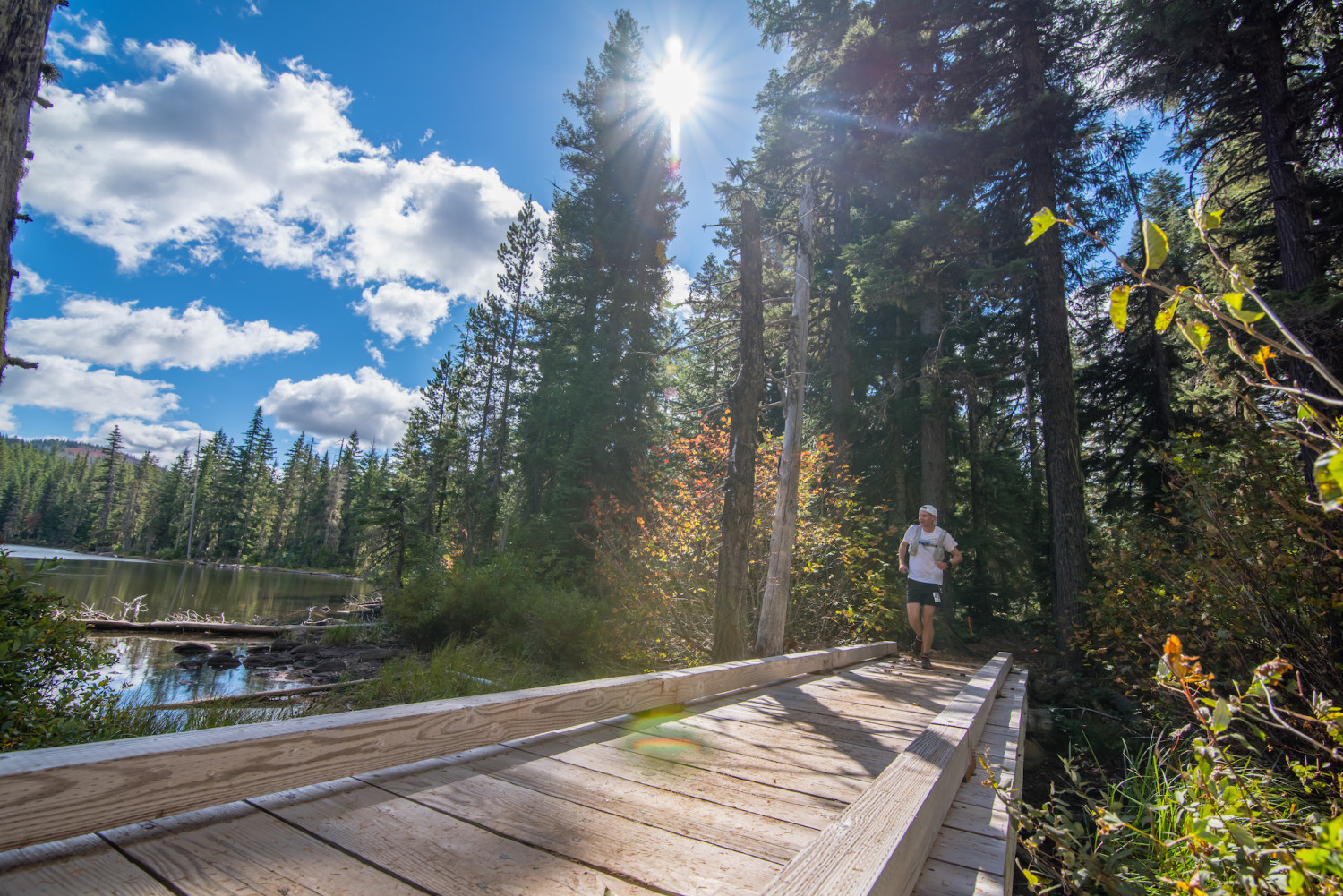
We’re thrilled and fortunate to return to Olallie Lake for the start/finish of the race. The area was burned in the 2020 Lionshead fire and wasn’t available to us for the 2021 and 2022 races. We will start and finish at Olallie Lake and get to take you on the Pacific Crest Trail south of the lake for a modified loop of our original route. You are in for one of the most beautiful finish lines you’ll ever experience.
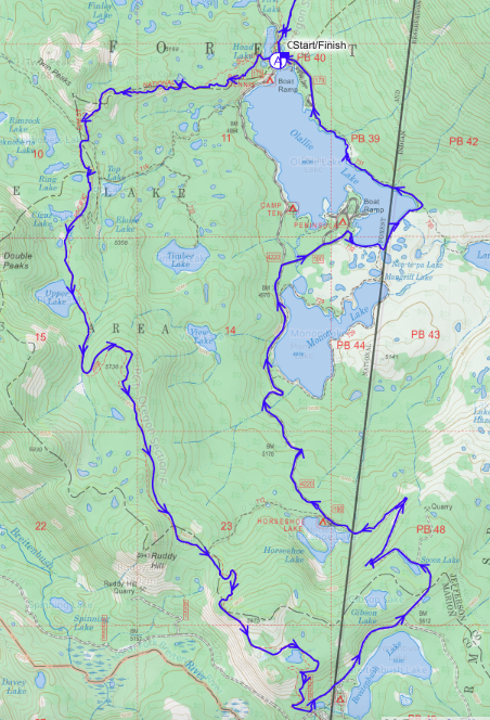
This Caltopo map is the best way to see the course. You can zoom in and out, move around, change the layers to view it differently: Online Interactive Mountain Lakes 100 Course Map
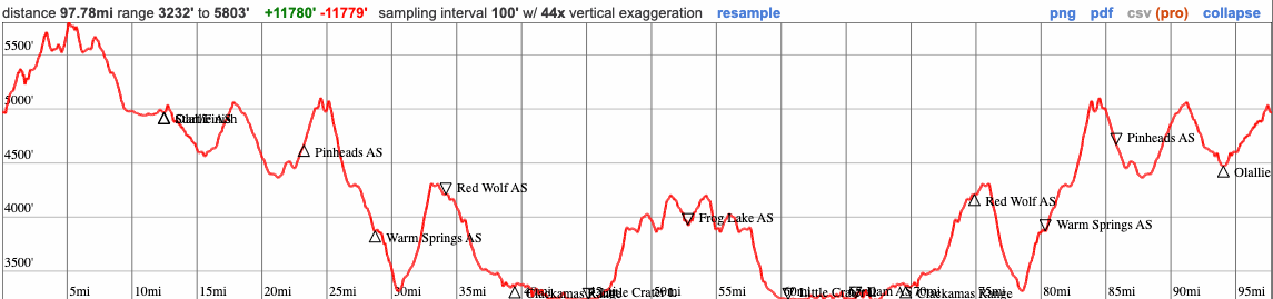
This race is 101 miles. The distances between aid stations come from maps, not GPS readings. Everyone’s GPS watch will report different distances. The Caltopo map under-represents the actual total distance. Trust us, you’ll run 101 miles.
And for COROS watch users, you can download the route directly to your COROS app and then sync to your watch.
11,700 feet of gain and loss.
All aid stations are stocked with Precision Fuel gels, Precision Hydration electrolyte drink, water, soft drinks, PB&Js, potato chips, pickles, Fritos, gummy bears, Oreos, fruit, Fig Newtons, M&Ms, and other ultra fare. There is also warm food (chicken and veggie broth, mashed potatoes, quesadillas, perogies, etc.) available during the night.
| Aid Station | Segment Distance |
Total Distance |
Elevation Gain |
Elevation Loss |
Crew Access | Porta-Potty | Drop Bag | Cutoff |
|---|---|---|---|---|---|---|---|---|
| Start | ||||||||
| Olallie Lake | 12.2 | 12.2 | 1611 | 1618 | Yes | Yes | Yes | |
| Pinheads | 10.2 | 22.4 | 1065 | 1348 | No | No | No | |
| Warm Springs | 7.2 | 29.6 | 572 | 1380 | No | No | No | |
| Red Wolf | 5.5 | 35.1 | 1070 | 727 | No | No | No | |
| Clackamas | 5.3 | 40.4 | 143 | 996 | Yes | Yes | Yes | 8:00 p.m. |
| Little Crater Lake | 6.1 | 46.5 | 297 | 414 | No | No | No | |
| Frog Lake | 8.1 | 54.6 | 1248 | 568 | No | No | No | |
| Little Crater Lake | 8.1 | 62.7 | 568 | 1248 | No | No | No | |
| Dam | 5.0 | 67.7 | 280 | 269 | Yes | No | No | |
| Clackamas | 4.0 | 71.7 | 335 | 228 | Yes | Yes | Yes | 5:00 a.m. |
| Red Wolf | 5.3 | 77.0 | 996 | 143 | No | No | No | |
| Warm Springs | 5.5 | 82.5 | 727 | 1070 | No | No | No | |
| Pinheads | 7.2 | 89.7 | 1380 | 572 | No | No | No | |
| Olallie Meadows | 8.0 | 97.7 | 826 | 1028 | Yes | No | No | |
| Finish | 3.6 | 101.3 | 671 | 186 | Yes | Yes | Yes | 2:00 p.m. |
All aid stations are cupless; bring your own drinking cup/vessel if you want to take liquid aid. You can refill bladders and bottles. Read more about Go Beyond Racing going cupless.
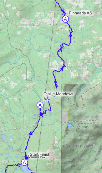
The course starts at the north end of beautiful Olallie Lake, at the Olallie Lake Resort picnic area, and heads north for a minute before you turn left onto the Pacific Crest Trail. You’ll run south on the PCT until you get to Forest Road 4220. From here, you loop back toward Olallie Lake, staying on the forest road until you get to the southern end of the lake, where you’ll run through the Penisula campground and get onto the Olallie Lake trail to get back to the start area for the aid station. All of this section is in the burn area with many lakes. You’ll notice how some portions are completely torched and others look somewhat untouched. There’s 1600′ of gain and loss.
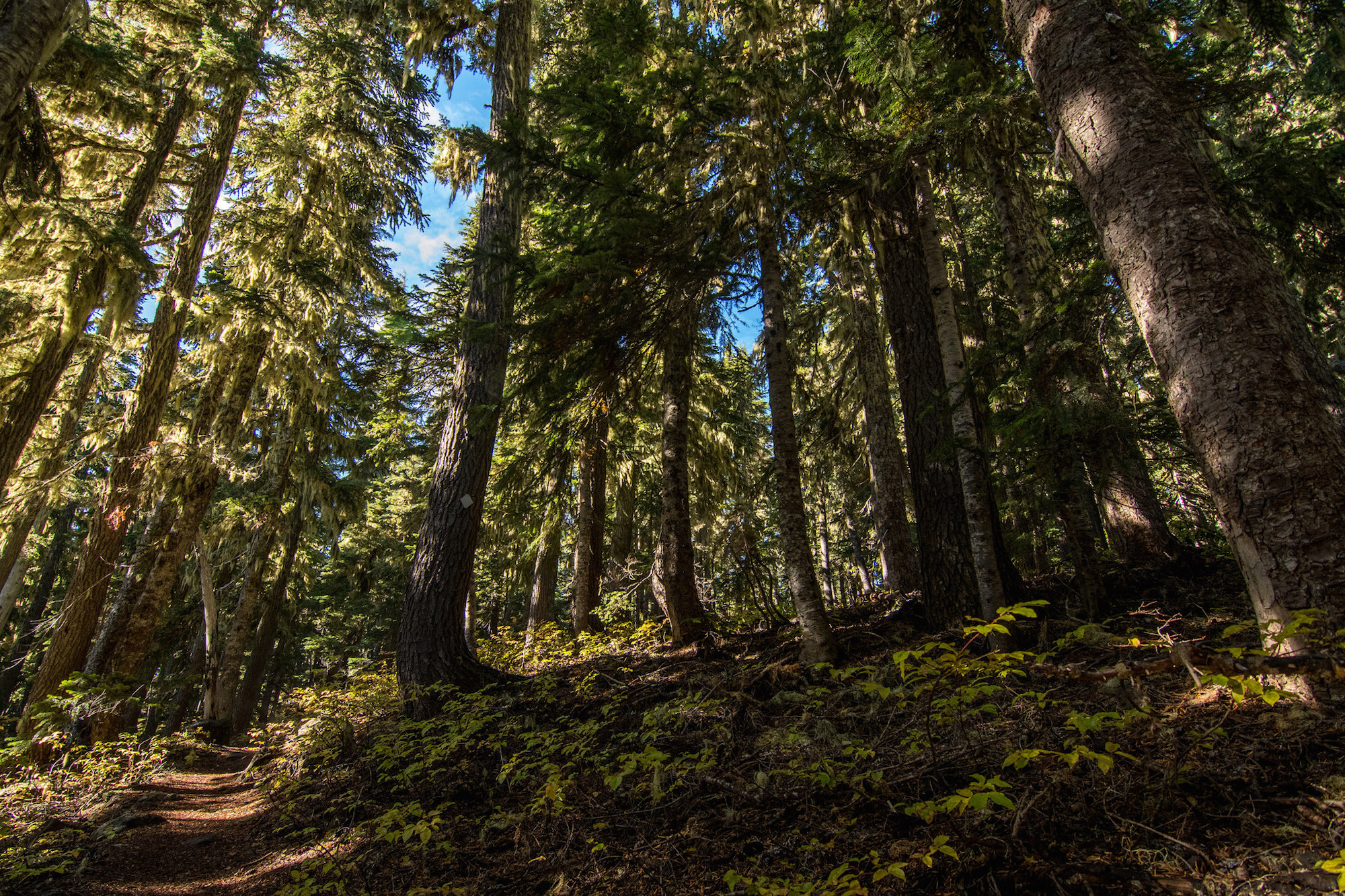
Leaving the aid station, you run north away from the resort and make a right onto the PCT. You’ll pass through the rest of burned section and then find yourself in lush green forest with a few more lakes.
There’s almost twice as much descent as gain as you continue on the PCT toward the Warm Springs aid station so this is a good section to let things flow.
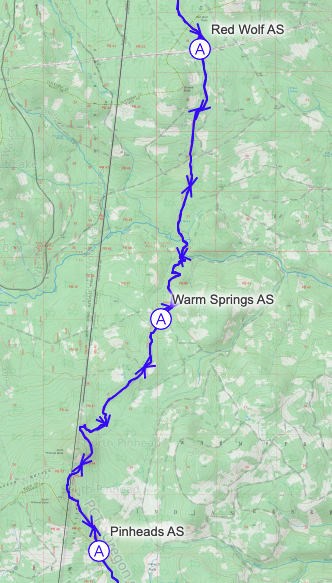
About two miles and 600 feet of descent after the aid station, you’ll cross the Warm Springs river. This is a great place to dip your hat if you’re hot. Then it is an ascent of 900 feet. The climb seems long. The trail eventually flattens out, passing clear cuts on the east side. You then drop slightly to the aid station, on the north side of power lines.
The trail descends over this section for almost 1,000 feet. It is gradually but noticeable. You could definitely make up time on this section if your legs have some reserves in them (but save them for the return trip to the finish). You’ll get off the PCT and onto the Miller trail at a 4-way junction and the run past the Clackamas Lake campground and carefully cross Skyline Rd to come around the back of the Historic Ranger Station that serves as the large aid station where crew await.
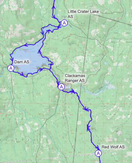
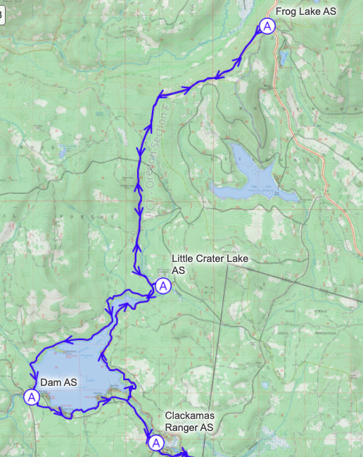
You leave the aid station the same way you entered, but turn right to continue onto the Miller trail, carefully crossing road 57. Continue for a short distance more on the Miller trail then make a right to descend to Timothy Lake’s edge. You’ll cross a bridge and get on the PCT again, continuing north with glimpses of the lake much of the way to the next aid station. For those who’ve run the race before, you’ll notice the difference this year with the Little Crater Lake aid station being at the parking area of the campground instead of right on the PCT. You’ll turn right on the connector trail to get to the campground, passing the amazing Little Crater Lake. Pause to notice how deep and clear it is!
Go back past Little Crater Lake and turn right onto the PCT. If you’re speedy enough to get here during the daylight, expect some great Mt. Hood views. This eight mile section has 1200+ feet of gain so it can feel a bit tough, but your half way done – way to go!
Back the way you came, to the Little Crater Lake aid station again, but this time you get to descend rather than climb.
Just a short distance after you get back onto the PCT from the aid station, you’ll take a right to get onto the Timothy Lake trail. From here, you’ll make your way around the lake, passing through a campground and running on some of the best trail surface of the race. On the western end of the lake, you’ll cross the dam to get to the aid station.
Departing the dam, you continue on the trail that goes around the lake. This section has some rocky areas and you’ll be tired, so pay attention to your footing. You’ll run along the lake’s edge and past several campgrounds. Carefully again cross Road 57 on the Miller trail to get back to the Ranger Station, crew, and maybe an awaiting pacer.
From here, it’s a return on the PCT where you’ve already run, but it’ll be a different time of day and for many, the sun will rise during this section and your energy will renew. When you get to mile 97, you’ll turn right off the PCT to go down to the Olallie Meadows aid station. This aid station is next to a cabin in the meadow and will give you what you need to make that final push to the finish line.
Go back up the trail to the PCT and turn right. You’ve come a long ways and it isn’t far to go, but of course it’ll feel like it is forever and all uphill. It’s not all uphill, but mostly, so put your head down and push, you are really, actually almost there.
There are three cutoffs:
Runners that do not depart prior to the cutoffs are not allowed to continue.
There are two drop bag locations; Olallie Lake mile 12 and at Clackamas miles 40 & 72. Drop bags are returned to the finish by 2 p.m. Sunday. Please don’t forget to grab yours before you leave.
Because drop bags are transported a few different times during a race, here are some best practices and restrictions around the size, quantity, and contents for Go Beyond Racing races.
Runners are allowed ONE crew vehicle. The course doesn’t requires two crew vehicles to support the racer and there is just not enough parking at the Clackamas Ranger Station or at Olallie Lake for that many cars. Please plan to utilize one vehicle for your crew, and ideally pacers, to get around the course. This may require some planning so don’t wait til the last minute to figure this out.
Crew vehicles must display their Crew Pass on the dashboard at all times during the race. These are picked up at bib pickup at Olallie Lake and at the Clackamas aid station.
Crew is allowed only at the following Aid Stations:
Crew and vehicles are not allowed at any of the other aid stations.
Runners whose crew access them anywhere on the course other than at the crew-accessible aid stations are disqualified. Make sure your crew know this!
Please review the parking information on the home page.
There is no internet or cell coverage at the race, so do not plan to access this page and click these links while at the race – you won’t be able to. Use them before you leave internet coverage and print or screen shot.
There is no online tracking of runners through the aid stations. This race is in the mountains and there is no internet and very limited cell service throughout. We keep track of the times runners go through the aid stations on paper and do have HAM radio operators at all the aid stations, for race operations purposes only. Crews will know when their runner arrives at the Clackamas Ranger, Dam, and Olallie Meadows aid stations – when they arrive. We encourage crews to take advantage of this time to connect, share stories, and interact with other crews, rather than staring at a screen to pass the time.
Runners are allowed to pick up a pacer at the Clackamas Aid Station #10 (as runners pass through the second time at mile 72), and at Olallie Meadows (for the final 3.6 miles the finish).
A pacer who joins you at the Clackamas Aid Station will run almost 30 miles, on a part of the course that doesn’t have crew access. If you drop your pacer, they will have to wait at the aid station until it shuts down and the volunteers can drive them out then.
Pacers must pick up Pacer Bibs and sign a waiver at the Clackamas or Olallie Meadows Aid Station prior to joining their runner. All Pacers must wear their Pacer Bib at all times when on course. Runners are allowed only one pacer to run with them at a time.
Muling is permitted. Pacers can eat and drink at the aid stations.
Pacers are responsible for their own transportation.
Your favorite person can wait for you just north of the Resort, where the PCT comes out onto road #4220, and run the final eighth-of-a-mile with you to the finish line.