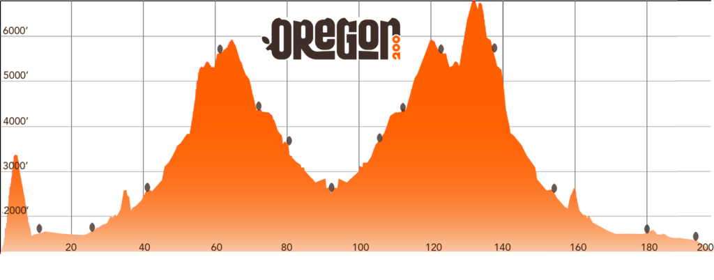
The Oregon 200 course is an out-and-back route through the Willamette and Umpqua National Forests. Much of the race is alongside the Middle Fork of the Willamette River, the North Umpqua River, and several lakes. You have 100 hours to finish the race! That’s a 30-minute mile average.
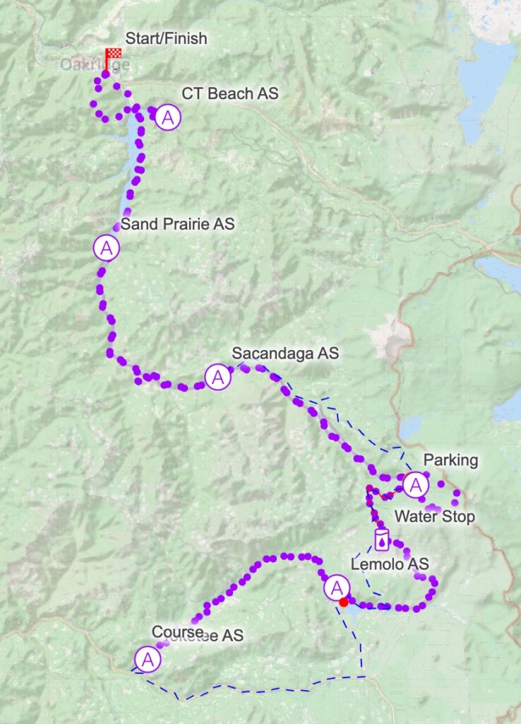
The race starts and finishes in Oakridge, at Greenwaters Park.
There are a few change to this year’s course, over last year’s:
Click here to view the Caltopo map of the course. You can zoom in and out and change the map layers (Forest Service, Satellite, Road, etc). You can also download a GPX file from the Caltopo map. You’ll want this for your phone and/or watch during the race.
There is 23,000′ feet of gain and loss. The low point is the start/finish line, at 1167′ and the highpoint is near the Cowhorn Mountain, on the Windy Pass trail on the Timpanogas loop, at 6,803′.
| Aid Station | Segment Distance |
Total Distance |
Gain (ft) |
Loss (ft) |
Crew Access |
Pacer | Cutoff |
|---|---|---|---|---|---|---|---|
| Start | |||||||
| CT Beach | 11.5 | 11.5 | 2620 | 2250 | Yes | No | |
| Sand Prairie | 13.0 | 24.5 | 670 | 690 | No | No | |
| Sacandaga | 18.0 | 42.5 | 2130 | 1210 | Yes | Yes | Sat 4:00 a.m. |
| Timpanogas 1 | 18.0 | 60.5 | 3260 | 450 | Yes/ Sleep |
Yes | Sat 1:00 p.m. |
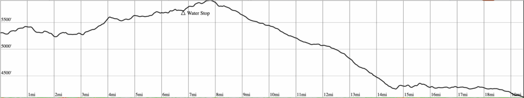
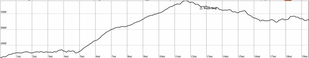
| Water Stop* | 7.0 | 67.5 | 1200 | 625 | Yes | No* | |
| Lemolo | 13 | 80.5 | 360 | 2150 | Yes/ Sleep |
Yes | Sat 11:00 p.m. |
| Toketee | 17.0 | 97.5 | 1980 | 3730 | Yes/ Sleep |
Yes | Sun 8:00 a.m. |
| Lemolo | 17.0 | 114.5 | 3730 | 1980 | Yes/ Sleep |
Yes | Sun 4:30 p.m. |
| Water Stop* | 13 | 127.5 | 2150 | 360 | Yes | No* | |
| Timpanogas 2 | 8.5 | 136 | 625 | 1200 | Yes/ Sleep |
Yes | Mon 2:30 a.m. |
| Timpanogas 3 | 11.0 | 145.5 | 1930 | 1930 | Yes/ Sleep |
Yes | Mon 8:00 a.m. |
| Sacandaga | 18.0 | 163.5 | 450 | 3260 | Yes/ Sleep |
Yes | Mon 4:30 p.m. |
| Sand Prairie | 18.0 | 181.5 | 1210 | 2130 | Yes/ Sleep |
Yes | Tue 1:30 a.m. |
| CT Beach | 13.0 | 194.5 | 690 | 670 | Yes | Yes | Tue 8:00 a.m. |
| Finish | 5.5 | 200 | 220 | 600 | Tue 11:00 a.m. |
*Pacers can stop here, but cannot start at the Water Stop. Pacers can only start at a full aid station where they can sign a waiver and get their bib. There are no amenities or staff at the Water Stop so pacers who drop here will need to find a ride on their own.
All aid stations will have at least the following:
In addition, each will have two “real food” offerings, for example; pancakes, burgers, tacos, rice bowls, hummus/veggies rollups. There is always a vegetarian and a vegan option.
All sleep stations are enclosed 10×10 or 10×20 tents with cots, sleeping bags or blankets, and heaters if needed.
*Water Stop is not an aid station. It is self-serve water only. There are no other amenities or items.
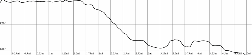
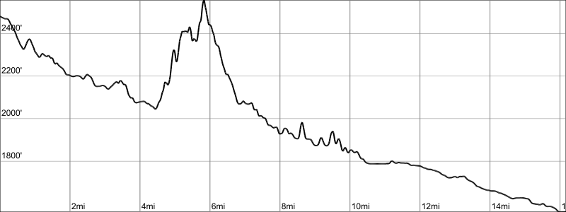
We’re going to make sure you don’t start off too fast. You’ve got a long way to go and it begins with a sturdy climb once you leave Greenwaters Park. You’ll gain about 2200′ in the first four and a quarter miles as you head up the Larrison Rock trail and then lose almost all of it on the way down to the first aid station at CT Beach Picnic Area. The descent is all pavement.
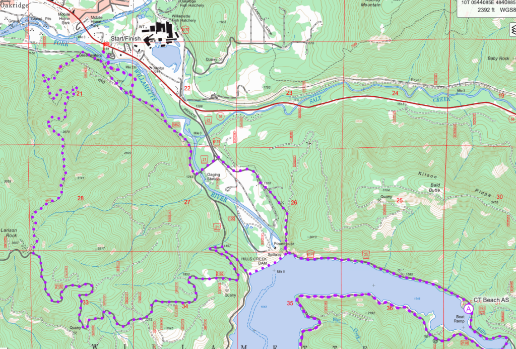
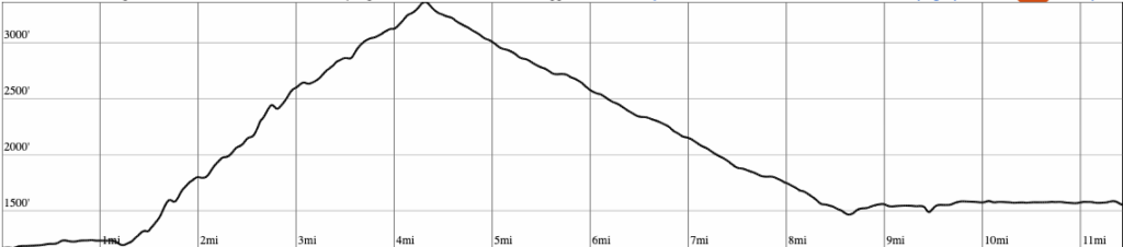
Shortly after leaving the aid station, you’ll cross a bridge and continue along the lake on a mostly flat forest road to the Sand Prairie campground/group picnic area. This section has pavement in the beginning and the end, and the middle is a dirt/gravel. There could be vehicles along the way, so be aware.
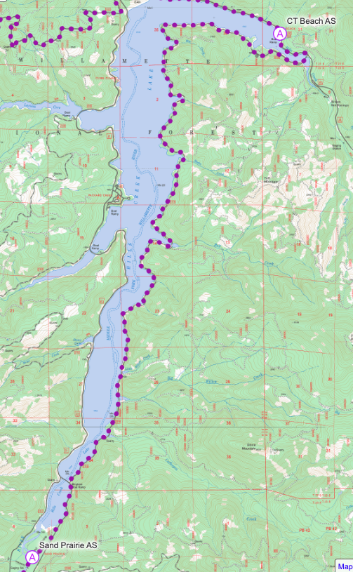
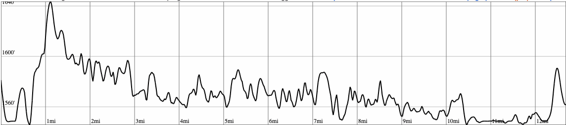
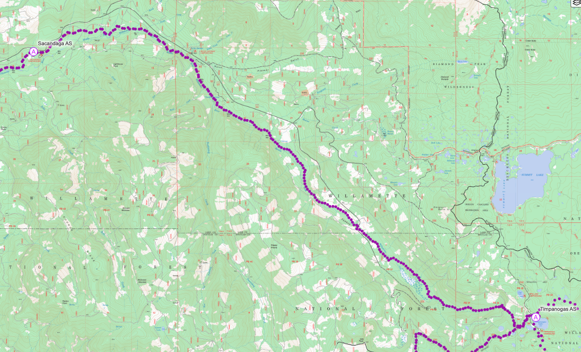
Leaving Sand Prairie puts you onto the Middle Fork trail. This is a National Recreation Trail and follows closely along the Middle Fork of the Willamette River. It’s a pretty gradual yet consistent ascent the whole way, with a steep climb up and over a big hill at mile 34, near the Campers Flat area. This spot also pulls away from the river for a bit and then you cross the river and continue onto the Sacandaga campground area for the next aid. There are lots of trail and road crossings here so pay attention to the course markings.
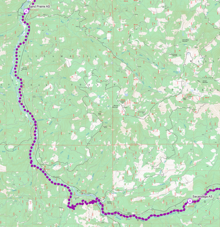
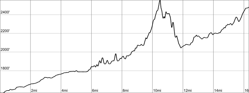
Fuel up well before leaving Sacandaga as you are about to gain a lot of elevation, over 3,000′. You’ll continue on the Middle Fork Trail, eventually passing Chuckle Spring (just try not to laugh) before arriving at Timpanogas Lake. The section is tough and is more technical (rooty and rocky) near the end.
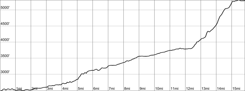
You’ll leave the aid station the same way you arrived and then turn left to head down forest road 2154 for a descent to Lemolo Lake. All but the last 5 miles is on a dirt/gravel forest road, but there are a few junctions so don’t space out too much and miss a turn. You’ll use forest roads 2154 to 770 to 700. There is an Water Only Aid Station 7 miles after leaving Timpanogas. This is not a full aid station, just self-serve water. Use it, as the road doesn’t have much tree cover and if it is daytime, you’ll get warm. You can also access your crew here.
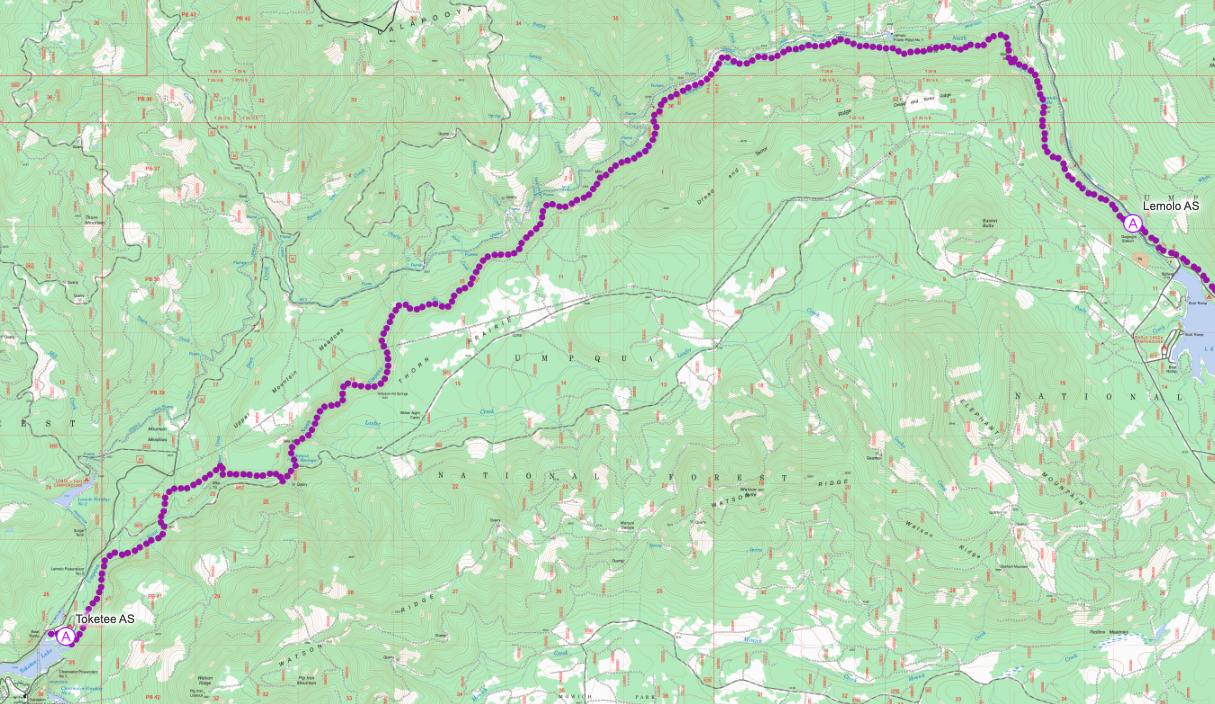
From the Water Only aid, go left onto 700 (crew will go right). Continue on Road 700 until it T’s into Road 60. Go right. After you pass the Kelsay Valley Campground entrance, you’ll get onto the North Umpqua Trail (NUT) and make your way along the north side of Lemolo Lake. You’ll pass through a burned area, from a 2024 fire. The aid station is beside the canal at the White Mule (aka Lemolo Falls) trailhead.
There could be other traffic on this section, especially ATV users, but we’ll have signs out alerting vehicles to your presence. They may still be driving fast and creating dust so be prepared.
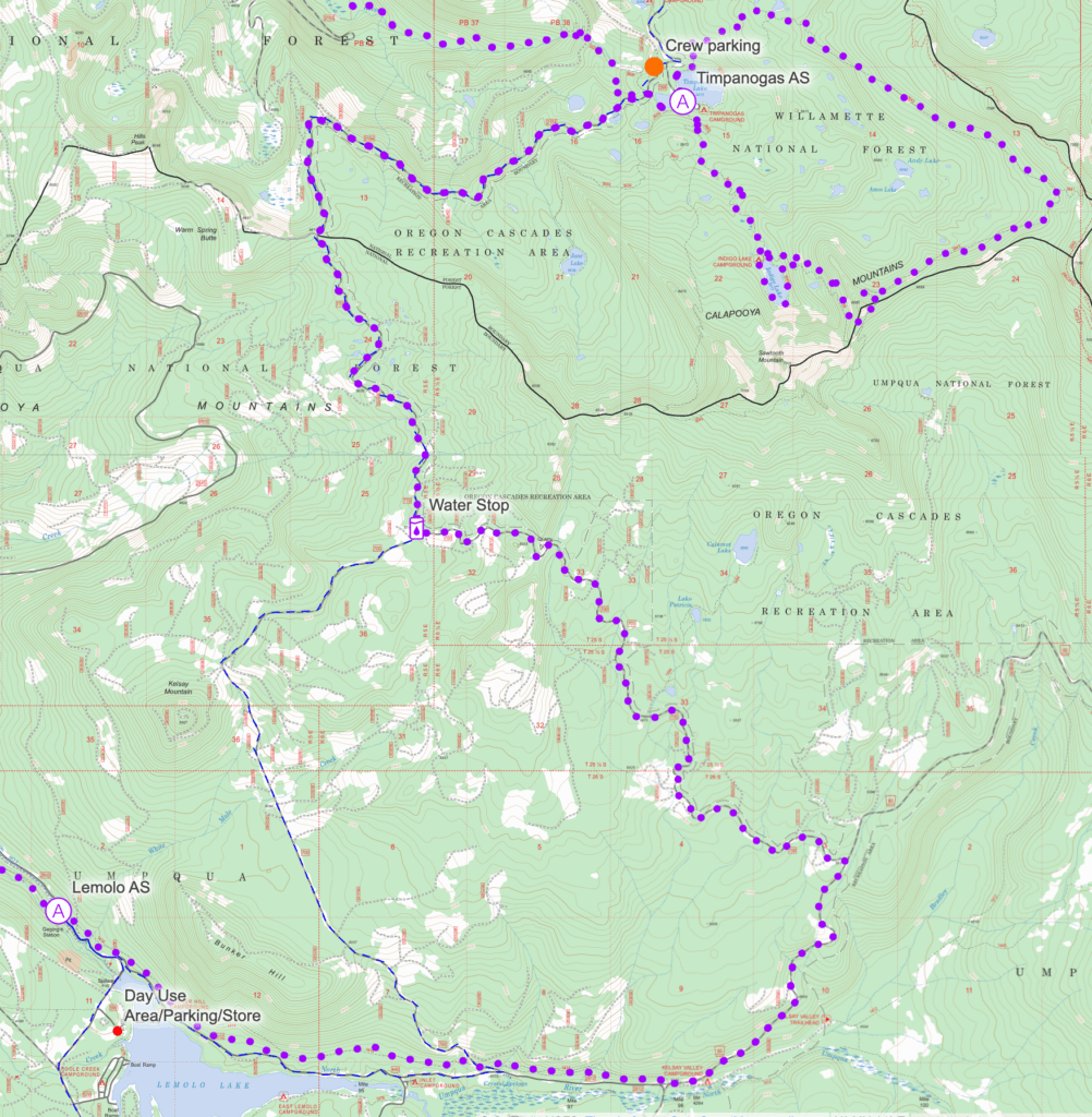
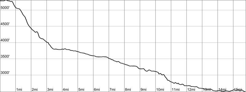
After refueling and resting, you continue on the NUT, heading west and descending along this very pretty river trail to Toketee Lake. It’s quite technical and rugged but with many lovely waterfalls to distract you. You’ll drop down to the river level and rise back above it over and over again, including a couple of very short water crossings. The trail has some sections with steep drop offs, so keep an eye on your footing, especially at night. You’ll pass through the popular Umpqua Hot Springs site (although you won’t go right by the springs/pools) before arriving at Toketee. The aid station is located at the boat ramp lot, just past the day-use area.
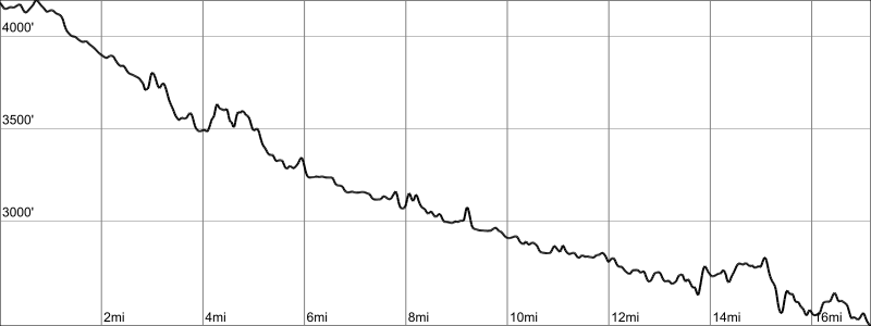
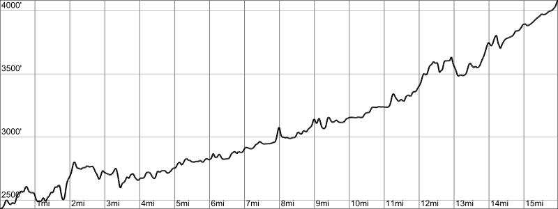
You’ll return the exact way you came back to the Lemolo Lake aid station except this time it is uphill. You’ll feel it too, being over half way through the race, so this is a good time to take it easy and appreciate the scenery and your impressive effort to get this far. Again, pay attention especially if in the dark.
You’re on your way up to Timpanogas now, with some final miles on the NUT before returning to the forest roads for some serious grinding. If you’re doing this section during the day, it can get pretty warm and your are exposed, so top off your fluids before leaving Lemolo and take advantage of the Water Stop aid (water only). Don’t forget that you’ll share the last 7 miles of this section with crew vehicles, and there could be other users on the road, like ATVs.
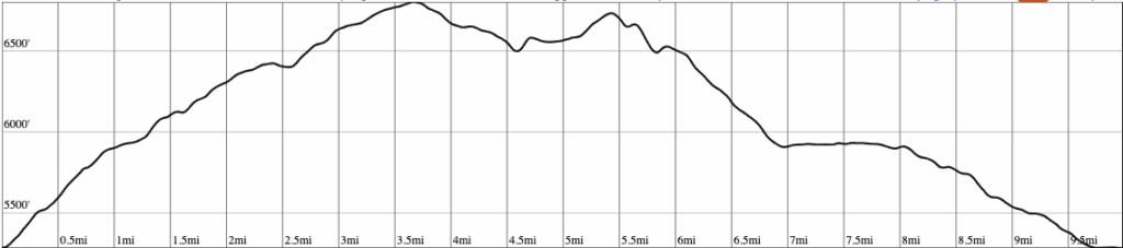
You’ll leave the aid station and start around Timpanogas Lake, and then climb up the Start O’ the Willamette trail (did you know Timpanogas Lake is the headwaters to the Middle Fork of the Willamette?). At the junction at the top, turn right onto the Windy Pass trail and make your way up to the high point of the course near Cowhorn Mountain (there’s cell service and great views here!). Then it’s over toward Sawtooth Mountain on the ridge and a fun descent to the prettiest little lake around, Indigo, with a rock hopping portion on its southern edge. You’ll take a clockwise lap around this lake and continue on back to the aid station at the Timpanogas. This is one of our favorite parts of the course – we hope you love it too.
Leaving the Timpanogas aid station for the final time, you’ll return to the Middle Fork Trail. Now you’re going downhill with the river. It’s been awhile so you may have forgotten this trail, but it’s more technical in the beginning than the end.
Finishing up the Middle Fork trail puts you back at the Sand Prairie picnic area and campground. You are so close. Relatively speaking of course. This section does have those intersections and junctions so keep your eyes on the markings.
You return to CT Beach by running alongside the lake. After your cross the bridge and get onto the pavement, be careful of potential traffic. You’ll be tired and probably not thinking super well and it could be dark, so use caution. This is your final aid station!
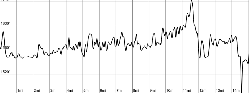
Leaving the aid station you continue north on Forest Road 23, passing (not going over) the dam, and then left onto Forest Road 21. This is where you’ll thank us for not making you climb up to the Larrison Rock trail. Instead, you’ll hang a right onto road 5852 for a mile before turning onto the trail into Greenwaters Park, the finish line, and the end of your 200-mile journey. You’re amazing!